Home | Category: Early Settlements and Signs of Civilization in Europe / Bronze Age Europe
ROUNDELS AND THE STROKED POTTERY CULTURE
Kristina Killgrove wrote in Live Science: The people who made Stroked Pottery ware are known for building other roundels in the Bohemian region of the Czech Republic, Řídký said. Their sedentary farming villages — located at the intersection of contemporary Poland, eastern Germany and the northern Czech Republic — consisted of several longhouses, which were large, rectangular structures that held 20 to 30 people each. But the "knowledge of building of roundels crossed the borders of several archaeological cultures," Řídký noted. "Different communities built roundels across central Europe." [Source: Kristina Killgrove, Live Science, September 21, 2022]
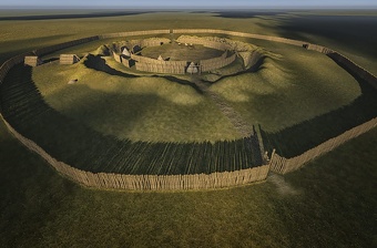
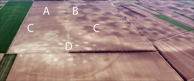
Roundels were not well-known ancient features until a few decades ago, when aerial and drone photography became a key part of the archaeological tool kit. But now, archaeologists know that "roundels are the oldest evidence of architecture in the whole of Europe," Řídký told Radio Prague International. Viewed from above, roundels consist of one or more wide, circular ditches with several gaps that functioned as entrances. The inner part of each roundel was likely lined with wooden poles, perhaps with mud plastering the gaps, according to Radio Prague International. Hundreds of these circular earthworks have been found throughout central Europe, but they all date to a span of just two or three centuries. While their popularity in the late Neolithic is clear, their function is still in question.
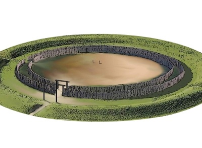
In 1991, the earliest known roundel was found in Germany, also corresponding to the Stroked Pottery culture. Called the Goseck Circle, it is 246 feet (75 m) in diameter and had a double wooden palisade and three entrances. Because two of the entrances correspond with sunrise and sunset during the winter and summer solstices, one interpretation of the Goseck Circle is that it functioned as an observatory or calendar of sorts, according to a 2012 study in the journal Archaeological Papers of the American Anthropological Association.
Řídký preferred a more general interpretation of the Vinoř structure, noting that "roundels probably combined several functions, the most important being socio-ritual," he told Live Science. It is likely that roundels were built for gatherings of a large number of people, perhaps to commemorate events important to them as a community, such as rites of passage, astronomical phenomena or economic exchange.
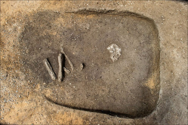
Given that the people who built roundels had only stone tools to work with, these roundels' sizes are quite impressive — most commonly, about 200 feet (60 m) in diameter, or half the length of a football field. But little is known about the people themselves, as very few burials have been found that could provide more information about their lives seven millennia ago.
After three centuries of popularity, roundels suddenly disappeared from the archaeological record around 4600 B.C. Archaeologists do not yet know why the roundels were abandoned. But considering over one-quarter of all roundels found to date are located in the Czech Republic, future research similar to the excavation at Vinoř may eventually help solve the mystery of the roundels.
See Separate Article: NEOLITHIC AND BRONZE AGE GERMANY AND CENTRAL EUROPE europe.factsanddetails.com
RECOMMENDED BOOKS:
“The Early Neolithic of Northern Europe: New Approaches to Migration, Movement and Social Connection” by Daniela Hofmann, Vicki Cummings, et al. (2025) Amazon.com;
“Monuments in the Making: Raising the Great Dolmens in Early Neolithic Northern Europe” by Vicki Cummings and Colin Richards (2021) Amazon.com;
“Dolní Vestonice–Pavlov: Explaining Paleolithic Settlements in Central Europe”
by Jirí A. Svoboda Amazon.com;
“The Life and Journey of Neolithic Copper Objects: Transformations of the Neuenkirchen Hoard, North-East Germany (3800 BCE) by Henry Skorna (2023) Amazon.com;
“Ancestral Journeys: The Peopling of Europe from the First Venturers to the Vikings” by Jean Manco (2016) Amazon.com;
“Northern Archaeology and Cosmology: A Relational View” by Vesa-Pekka Herva, Antti Lahelma Amazon.com;
“Ancient DNA and the European Neolithic: Relations and Descent” by Alasdair Whittle, Joshua Pollard (2023) Amazon.com;
“Key to Northwest European Origins” by Raymond F McNair (2012) Amazon.com;
“The First Farmers of Central Europe: Diversity in LBK Lifeways” by Penny Bickle, Alasdair Whittle Amazon.com;
“Seeking the First Farmers in Western Sjælland, Denmark: The Archaeology of the Transition to Agriculture in Northern Europe” by T. Douglas Price (2022) Amazon.com;
“TRB Culture: The First Farmers of the North European Plain” by Magdelina S. Midgeley (1992) Amazon.com;
“Gods and Myths of Northern Europe” by H.R. Ellis Davidson (1965) Amazon.com;
“The Earliest Europeans: A Year in the Life: Survival Strategies in the Lower Palaeolithic (Oxbow Insights in Archaeology) by Robert Hosfield (2020) Amazon.com;
“First Migrants: Ancient Migration in Global Perspective” by Peter Bellwood Amazon.com;
“Foragers and Farmers: Population Interaction and Agricultural Expansion in Prehistoric Europe” by Susan A. Gregg (1988) Amazon.com;
“The Neolithic Transition and the Genetics of Populations in Europe (Princeton Legacy Library)” by Albert J. Ammerman and L L Cavalli-sforza (2016) Amazon.com;
“The Oxford Handbook of Mesolithic Europe” by Liv Nilsson Stutz, Rita Peyroteo Stjerna, et al. (2025) Amazon.com;
“Mesolithic Europe” by Geoff Bailey and Penny Spikins (2008) Amazon.com;
“Who We Are and How We Got Here: Ancient DNA and the New Science of the Human Past” by David Reich (2019) Amazon.com;
“The Oxford Handbook of Neolithic Europe” by Chris Fowler, Jan Harding, Daniela Hofmann (2015) Amazon.com;
“European Societies in the Bronze Age” by A. F. Harding (2000) Amazon.com;
“The Oxford Handbook of the European Bronze Age” by Anthony Harding and Harry Fokkens (2020) Amazon.com;
“Organizing Bronze Age Societies: The Mediterranean, Central Europe, and Scandanavia Compared” by Timothy Earle, Kristian Kristiansen Amazon.com;
Goseck Circle
The Goseck Circle is a Neolithic structure dated to 4900 B.C. in Goseck in the Burgenlandkreis district in Saxony-Anhalt, Germany. Comprised of ringed ditches and wooden palisades it has been described as the oldest of Europe’s Neolithic circles, which includes Stonehenge. The circle was discovered in 1991 by Otto Braasch on an aerial survey photograph. Its existence was made public in August 2003. It was opened for visitors in December 2005. The Goseck ring is one of the best preserved and extensively investigated Neolithic circle. Approximately 140 of these structures, known as circular enclosures, have been found. Although they all have unique features, they follow a basic architectural principle. Few of them have been excavated. .[Source: Wikipedia]
Used for about 200 years until about 4700 B.C., the Goseck Circle , the circle consists of a concentric ditch 75 meters (246 feet) across and two palisade rings containing entrances in places aligned with sunrise and sunset on the winter solstice days and smaller entrances aligned with the summer solstice. Some have called it the oldest "Solar observatories" in the world, but sunrise and sunset during winter and summer solstices are the only astronomical alignments thus far found at the structure.
The Goseck Circle sits on a piece of land that gradually rises toward the south, not far from where the Unstrut River flows into the Saale River, at the border of the region known as Leipzig Bay. Pottery shards associate it with the stroke-ornamented ware culture of ca. 4700 B.C. Excavations have revealed remains of what may have been ritual fires, animal and human bones. A headless skeleton near the southeastern gate may have been from burial ritual or a human sacrifice.
The Goseck Circle site is surrounded by a circular V-shaped moat of up to 1.8 meters deep. The diameter of the moat is 75 meters. A double wooden palisade stood inside the moat. No traces of internal buildings were found. Entry to the site was via three symmetrical main entrances to the north, southwest, and southeast. In addition there were small gaps in the palisades allowing access. The moat followed the three main entries outward. The entrances in the inner palisade were narrower than those in the outer, which in turn, were narrower than the gap in the moat. The southwestern and southeastern entrances face the direction of sunset and sunrise around the date of the winter solstice. Two of the smaller breaks in the wall face toward the equivalent direction on the summer solstice.There is no sign of fire or of other destruction. Why the site was abandoned is unknown. Later villagers built a defensive moat following the ditches of the old enclosure.
The construction of Goseck Circle corresponds to the transitional phase between the Neolithic Linear Pottery and Stroke-ornamented ware cultures. The site is one of a larger group of circular enclosures in the Elbe and Danube region, most of which show similar solstice alignments. There has been some debate about whether the site was used to monitor the sun throughout the year or only on specific notable days, and thus about whether calling the site a "solar observatory" is justified. Archaeologist Ralf Schwarz suggests the structures at the site allowed coordinating an easily judged lunar calendar with the more demanding measurements of a solar calendar through calendar calculations. Today, the reconstructed site is open to the public. An information point has been opened at nearby Schloss Goseck, featuring an exhibit and information on the excavations.
Bronze Age Network of Huge Megaforts in Central Europe
In a study published in the journal PLOS One in January 2024, scientists described a Bronze Age societal network of megaforts in Central Europe that they gained an understanding of using satellite imagery. An archaeological team discovered over 100 sites in a complex network containing some of the largest structures in the world at that time. The “massive sites did not stand alone, they were part of a dense network of closely related and codependent communities,” Barry Molloy, one of the authors of the study said, “At their peak, the people living within this lower Pannonian network of sites must have numbered into the tens of thousands.” [Source: Tim Newcomb, Popular Mechanics, January 29, 2024] . Tim Newcomb wrote in Popular Mechanics: Some of the largest megaforts — like Gradište Iđoš, Csanádpalota, Sântana, or Corneşti Iarcuri — were enclosed by over 20 miles of ditches and were the largest of the Bronze Age. They were located in the Carpathian Basin, which extends across central and southeast Europe and is cut through by the Danube River. Similar to the way that 396 previously unknown Roman forts were exposed in modern-day Syria and Iraq through Cold War-era satellite imagery, unlocking over 100 new sites in Central Europe is a feather in the cap of technology-assisted archaeology, and expands our understanding of ancient societal networks.
The new finds were all located near the Tisza River, which now extends through several national boundaries, all within 50 miles of one another. Through ground surveys, excavation, and geophysical prospection, the team established that most of the sites were established between 1600 and 1450 B.C., and were likely maintained until an en masse abandoning around 1200 B.C.. The tight proximity leads archaeologists to the conclusion that this wasn’t a highly contested region of multiple kingdoms, but rather a cooperative community that served as a major hub for the region at a time when the Mycenaeans, Hittites, and New Kingdom Egyptians all enjoyed success. “Our understanding of how their society worked challenges many aspects of European prehistory,” Molloy said. “It would be extremely unlikely for each of these 100-plus sites to have been individual chiefdoms competing with each other.”
This is made apparent, in part, by the level of detail in which the images were captured. “Uniquely for prehistoric Europe, we are able to do more than identify the location of a few sites using satellite imagery but have been able to define an entire settled landscape, complete with maps of the size and layout of sites, even down to the locations of people’s homes within them,” Molloy said. “This really gives an unprecedented view of how these Bronze Age people lived with each other and their many neighbors.”
The timing also lines up with a major turning point in Europe’s history — military and earthwork technologies spread across the continent, before collapsing around 1200 B.C.. This network of sites could help explain how an important group of people likely defined the material culture and iconography that spread across Europe. The scope of the sites may also challenge the leading theory on why the 1200 B.C. collapse occurred. Previously, it was believed that the abandonment of central places was due to diminishing populations. But the authors counter that the complexity and density in the settlement systems instead shows “increased scale” thanks to “intensified long-distance networks.” Of course, it wasn’t all white picket fences. “Major innovations in warfare and organized violence took place at this time,” Molloy said. “The scale of this society indicates it was relevant and powerful on a European stage and between force of arms and major defensible features at settlements, they were well equipped to defend their gains.”
11,000-Year-Old Megastructure Used in Reindeer Hunting Found in the Baltic Sea
Ashley Strickland of CNN wrote: Researchers and students from Kiel University in Germany first came across the surprising row of stones located about 69 feet (21 meters) underwater during a marine geophysical survey along the seafloor of the Bay of Mecklenburg, about 6 miles (9.7 kilometers) off the coast of Rerik, Germany. The discovery, made in the fall of 2021 while aboard the research vessel RV Alkor, revealed a wall made of 1,670 stones that stretched for more than half a mile (1 kilometer). The stones, which connected several large boulders, were almost perfectly aligned, making it seem unlikely that nature had shaped the structure. A study describing the structure was published in February 2024 in the journal Proceedings of the National Academy of Sciences.[Source: Ashley Strickland, CNN, February 13, 2024]
The team determined that the wall was likely built by Stone Age communities to hunt reindeer more than 10,000 years ago. “Our investigations indicate that a natural origin of the underwater stonewall as well as a construction in modern times, for instance in connection with submarine cable laying or stone harvesting are not very likely. The methodical arrangement of the many small stones that connect the large, non-moveable boulders, speaks against this,” said lead study author Dr. Jacob Geersen, senior scientist at the Leibniz Institute for Baltic Sea Research in Germany, in a statement.
The wall was likely built along the shoreline of a lake or a bog, according to the study. Rocks were plentiful in the area at the time, left behind by glaciers that had moved across the landscape. But studying and dating submerged structures is incredibly difficult, so the research team had to analyze how the region has evolved to determine the approximate age of the wall. They collected sediment samples, created a 3D model of the wall and virtually reconstructed the landscape where it was originally built.
Sea levels rose significantly after the end of the last ice age about 8,500 years ago, which would have led to the wall and large parts of the landscape being flooded, according to the study authors. “At this time, the entire population across northern Europe was likely below 5,000 people. One of their main food sources were herds of reindeer, which migrated seasonally through the sparsely vegetated post-glacial landscape,” said study coauthor Dr. Marcel Bradtmöller, research assistant in prehistory and early history at the University of Rostock in Germany, in a statement. “The wall was probably used to guide the reindeer into a bottleneck between the adjacent lakeshore and the wall, or even into the lake, where the Stone Age hunters could kill them more easily with their weapons.” The hunter-gatherers used spears, bows and arrows to catch their prey, Bradtmöller said.
A secondary structure may have been used to create the bottleneck, but the research team hasn’t found any evidence of it yet, Geersen said. However, it’s likely that the hunters guided the reindeer into the lake because the animals were slow swimmers, he said. And the hunter-gatherer community seemed to recognize that the deer would follow the path created by the wall, the researchers said. “It seems that the animals are attracted by such linear structures and that they would rather follow the structure instead of trying to cross it, even if it is only 0.5 meters (1.6 feet) high,” Geersen said.
Massive 5,000-Year-Old Cemetery Discovered in Poland
Scientists discovered a gigantic, 5,000-year-old complex of long barrows and stone-lined tombs in Poland by investigated lines in crops in a field that they'd seen in a satellite photograph.Tom Metcalfe wrote in Live Science: Archaeologists began to excavate the rural site near the town of Dębiany, about 30 miles (50 kilometers) northeast of Kraków in 2019, By 2021 they’d unearthed seven Neolithic tombs and a Bronze Age burial of two horses. But the full extent of the ancient cemetery isn't yet known.[Source: Tom Metcalfe, Live Science, March 25, 2021]
The archaeologists now think it consists of a dozen barrow mounds, each between 130 feet and 160 feet (40 meters and 50 meters) long, made from earthworks, stones and palisades of wooden poles that have now rotted away. They think it's a relic of the prehistoric settlement of the area by the Neolithic Funnel Beaker people, who are named after the distinctive pottery vessels they made and are thought to have been the first farmers in Europe. "The megalithic cemetery in Dębiany is one of the largest and most interesting sites of this type in Central Europe," archaeologists Marcin Przybyła and Jan Bulas told Live Science in an email. "It provides us with extraordinary data on the funeral customs of the Funnel Beaker Culture."
The barrows and tombs of the Neolithic cemetery were found to the north and south of the fortress during excavations of the site. Bulas, an independent archaeologist in Kraków, first noticed that straight lines visible in a satellite photograph of the field — the result of subtle differences in the growth of the crops — could be caused by the underground remains of a four-sided structure. Bulas and Przybyła visited the site and used magnetic gradiometers to measure tiny variations in the Earth's magnetic field and reveal where the underlying ground had been disturbed in the past.
Although they have now eroded into the landscape, the barrows were once much higher, Przybyła told Science in Poland. They were made by piling earth above a central stone-lined tomb, and were reinforced with palisades of wooden poles; the poles have now rotted away and only traces of their post-holes remain. The researchers have yet to find any skeletal remains in the central tombs, but they did detect traces of Neolithic burials in the embankments of earth that surrounded them, Przybyła said. Przybyła and Bulas told Live Science that the archaeological team had also recently unearthed a grave at the site where two horses were buried side by side, along with part of a bridle. They've dated that grave to the middle of the Bronze Age in the region, about 3,500 years ago.
The Funnel Beaker people who built the ancient barrows near Dębiany, Poland spread throughout central Europe from about 4100 B.C. It's thought they were farming people who migrated to the region from what is now Spain and France, and who were themselves descendants of people who had migrated from the Balkans, where they had adopted earlier farming practices from the Middle East. Archaeologists have unearthed long barrow cemeteries made by Funnel Beaker people elsewhere in Poland, as well as in Germany and southern Scandinavia. One of the best known is hidden in a forest in the central Polish region of Kujawy — the enormous burial mounds are sometimes called the Polish pyramids. But it's thought that the ancient cemetery near Dębiany could be one of the largest complexes of Funnel Beaker barrows yet found, Przybyła said.
6000-Year-Old Burial in Germany Where Cattle Were Sacrificed
In 2024, researchers announced the discovery a massive Neolithic burial site, with a chariot and human remains, which was located on a processional route where cattle were sacrificed. The excavation site is located at an industrial park near Magdeburg, the capital of the German state of Saxony-Anhalt. It includes a pair of 6,000-year-old "monumental mounds" that contain multiple burials. Information on the site came from the State Office for Monument Preservation and Archaeology of Saxony-Anhalt. [Source: Jennifer Nalewicki, Live Science, March 20, 2024]
Jennifer Nalewicki wrote in Live Science: One burial in particular stands out, and researchers think it could be part of a ritualistic offering. This conclusion is based on the unique positioning of the skeletal remains of a man who was 35 to 40 years old when he died, two cattle and a chariot, which were placed in such a way to create "the image of a cart with a driver or a plow pulled by cattle," according to the statement.
Researchers stressed the importance of the burial, since it "symbolize[s] that with the cattle the most important possession, the security of one's own livelihood, was offered to the gods," they wrote in the statement. Archaeologists traced one of the burial mounds to the people behind the Baalberg (also spelled Baalberge) group, a Neolithic culture that existed in Germany between 4100 and 3600 B.C. That mound includes two large, trapezoidal wood burial chambers measuring 20 meters (66 feet) long and 30 meters (98 feet) long. Each chamber is spaced approximately 660 feet (200 meters) apart. About 5,000 years ago, the expanse separating the two burial mounds was used as a "processional route where cattle were sacrificed, and people [were] buried," according to the statement. Researchers called the ritualistic usage of this area "astonishing" and concluded that the area was "important for prehistoric people over a long period of time."
Germany’s Stonehenge
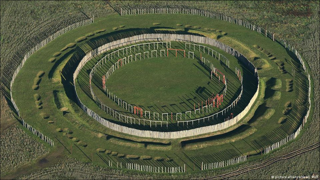
Sometimes referred to Germany’s Stonehenge, Ringheiligtum Pömmelter (Pömmelte ring sanctuary) is Stonehenge-like astronomical observatory, built in wood, whose earliest phase has been radiocarbon dated to 2300 B.C. Only discovered in 1991. It is located near the village of Pömmelte, in the district of Salzlandkreis in Saxony-Anhalt, Germany. Candida Moss wrote in the Daily Beast: Like Stonehenge, it is concentric and is made up of seven rings of raised banks, ditches, and palisades in which wooden posts were positioned. If you visit the 380-feet-wide circle today you can see the attractive reconstructed monument. The painted wooden posts erected at the site give tourists a sense of what it was like in its heyday. [Source: Candida Moss, Daily Beast, June 20, 2021]
Like Stonehenge the orientation of the site appears to have been determined by the summer and winter solstices. Thus, until recently, archaeologists assumed that Ringheiligtum was a ritual site that was used for religious purposes, stargazing, and the celebration of seasonal festivals. It was essentially a sacred flex space. Excavations reported in June 2021 by Heritage Daily, have revealed that people actually lived there. During the course of the May 2021 excavations scientists have discovered 130 dwellings (80 of which are complete), 20 ditches, and two burials. The newly discovered structures were built between 2800 B.C. and 2200 B.C., with most of the houses dating to the latter period.
What makes the presence of homes especially noteworthy is the character of the religious rituals performed at Ringheiligtum. Between 2005 and 2008 excavations sponsored by the State Office for Cultural Heritage Management in Baden-Württemberg and the Martin Luther University in Halle-Wittenberg (both in Germany) probed the secrets of the site. It was these excavations that discovered the 300-year period of use and the post holes for the wooden fences and poles that have since been rebuilt. Other objects — including, grinding stones, millstones, stone axes, ceramic vessels, and animal bones were found in the pits.
What remains unknown is the relationship between the Ringheiligtum at Pömmelte and the Stonehenge in Wiltshire, England. If you grew up thinking that Stonehenge was special, you were wrong. Stonehenge was important and drew visitors from all across Britain, but it was far from unique. Though there are clear differences between the German and British examples the similarities are also apparent: concentric circles, monumental structures, religious rituals, and human remains buried in the system of pits and posts. The larger question of the relationship between and emergence of this symbolic sacred architecture remains unresolved. Stonehenge and the Woodenhenge at Pömmelte are not alone either. There are other circular monuments in the UK (the UK has its own Woodenhenge) and there is the 7,000-year-old Goseck circle in Germany.
In sum, symbolic architecture and Neolithic solar observatories aren’t particular to the British Isles and seem to have originated in mainland Europe. The existence of other henges suggests that Neolithic and Bronze Age Europe was more interconnected than previously realized. As people migrated, they took their symbolic architecture and astrological-religious thought with them to new sites. And at some of those sites people — mostly vulnerable members of the community or outsiders — met grisly ends.
Grisly Activities at Germany’s Stonehenge
Researchers made several macabre discoveries at the German Stonehenge, including the dismembered remains of 10 children and women. Candida Moss wrote in the Daily Beast: The researchers also uncovered more macabre finds, in particular the dismembered remains of 10 children and women. Osteoarcheological analysis of the remains revealed that four of those buried there had suffered trauma to their skulls and ribs close to the time of their deaths, suggesting that they had died violently. While archaeologists uncovered more formal burials of 13 male adults within the east side of the rings of the Ringheiligtum, the internment of the women and children was different. Their bodies were thrown indiscriminately into the pits leading some to suggest that they had been ritually sacrificed as a part of the rituals that took place there. [Source: Candida Moss, Daily Beast, June 20, 2021]
According to study on the subject it remained “unclear whether these individuals were ritually killed or if their death resulted from intergroup conflict, such as raiding.” But the difference between the male and female burials were suggestive: “the gender-specific nature of the adult victims and the ritual nature of the other deposits make [ritual sacrifice] a likely scenario.”
According to André Spatzier, an archaeologist at the State Office for the Preservation of Historic Monuments at Baden-Württemberg, these victims were thrown or pushed into the pit. At least one individual was found with bound hands, which might suggest that he was alive when he was buried. Many of the remains had fractured skulls and rib bones and were buried alongside drinking vessels, animal bones, and axes. It is possible that those buried in the mass graves were killed in a raid or violent clash of some kind. But if this is the case, it is extraordinary that there are no adult men among those killed. The fact that ritual items were found there also suggests that this is no ordinary grave, argued Spatzier. A nearby burial site of men contained none of the ritual objects that make this site so remarkable. [Source: Candida Moss, Daily Beast, July 14, 2018]
Regardless of how you read the evidence, there was a clear disjuncture between the respectful burial afforded the men who were buried there, and the more dismissive and traumatic deaths of the women and children who may have been sacrificed (or executed). What the new excavation reveal is that whatever happened at Pömmelte, however violent, took place in close proximity to people’s homes. That the ritual sacrifice of women and children may have been taking place so close to domestic space (which is traditionally conceived of as the domain of women), is thought-provoking and suggestive. It’s easy to imagine the implicit threat that the memory of these violent rituals posed to the women who lived nearby.
Image Sources: Wikimedia Commons except the the roundel from Institute of Archaeology of the Czech Academy of Sciences
Text Sources: National Geographic, Wikipedia, New York Times, Washington Post, Los Angeles Times, Smithsonian magazine, Nature, Scientific American. Live Science, Discover magazine, Discovery News, Natural History magazine, Archaeology magazine, The New Yorker, Time, Newsweek, BBC, The Guardian, Reuters, AP, AFP and various books and other publications.
Last updated May 2024

