Home | Category: Themes, Archaeology and Prehistory / Science and Nature
GEOGRAPHY OF GREECE
The Greeks have often been described as “independent-minded” and there seems no doubt that geography played a major role in shaping that character. It was the mountains and the sea that molded Greece and Greeks into what they were. Mountains in Greece don't soar to the heights of other mountain ranges such as the Andes, Rockies, Alps or Himalayas-but they are extensive. In fact, about 80 percent of Greece is covered with mountains with the result that most settlements were less than 10 miles from a mountain. These mountain ranges isolated regions from each other more effectively than fences because what they lack in height they make up with steepness and ruggedness preventing or discouraging overland travel and communication.” [Source: Canadian Museum of History ]
Occupying the southernmost tip of Europe and bordered by Albania, Macedonia and Bulgaria to the north, Turkey and the Aegean Sea to the east, the Ionian Sea to the west, and the Mediterranean Sea to the south, modern Greece covers an area of 51,182 square miles (about the size of Alabama). Ionian Sea and Aegean Sea are branches of the Mediterranean Sea. The Ionian Sea is south of the Adriatic Sea between Italy and Croatia and Albania.
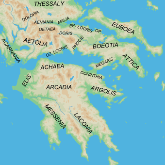
Greece is broken up into six major regions-1) Thrace, Macedonia, Thessaly, Epirus in the north; 2), central Greece, including Thessaly; 4) the Peloponnesus; and 4) and the Greek islands in the Aegean Sea to the east and the Ionian Sea in the west. The mountainous northern part of Greece is considered part of the Balkans. Thrace, formerly part of Turkey, and Macedonia are south of Bulgaria on the eastern Greek panhandle. Epirus is south of Albania.
Few Classical Greek cities were located right on the water because of worries about piracy and hostile raids. Even a city that traded extensively still had to transport cargo to and from its port. The road between Athens and Corinth, two of the main city-states in ancient Greece, was a narrow and treacherous path along sheer seaside cliffs, probably suitable only for pedestrians and pack animals, and any wheeled traffic had to take a more circuitous inland route. In the A.D. 2nd century, Pausanias described the roadways around the major religious shrine at Delphi. Delphi is located in a particularly mountainous area and the roads as described by Pausanias were generally difficult. [Source Encyclopedia.com]
RECOMMENDED BOOKS:
“Ancient Geography: The Discovery of the World in Classical Greece and Rome” (2017)
by Duane W. Roller Amazon.com;
“The Penguin Historical Atlas of Ancient Greece” by Robert Morkot (1997) Amazon.com;
“Strabo's Geography: A Translation for the Modern World Hardcover”
by Strabo, translated by Sarah Pothecary Amazon.com;
“Delphi Complete Works of Strabo - Geography (Illustrated)” Kindle Amazon.com;
“A Historical and Topographical Guide to the Geography of Strabo”
by Duane W. Roller (2024) Amazon.com;
“The Ancient Mediterranean” by Michael Grant (1988) Amazon.com;
“The Greeks and Greek Civilization” by Jacob Burckhardt (1902) Amazon.com;
“Oxford Companion to Classical Civilization” by Simon Hornblowwer and Anthony Spawforth Amazon.com;
“Ancient Greece: From Prehistoric Times to Hellenistic Times” by Thomas R. Martin (1996) Amazon.com;
“The Greek Way” by Edith Hamilton (1930) Amazon.com;
“The Shortest History of Greece” by James Heneage (2021) Amazon.com;
“Ancient Greece: A Political, Social, and Cultural History” by Sarah B. Pomeroy (1998) Amazon.com;
“Sailing Wine-Dark Sea: Why the Greeks Matter “ by Thomas Cahill, Illustrated (2004) Amazon.com;
“Ancient Greece: The Definitive Visual History” by DK (2025) Amazon.com;
“Histories” by Herodotus (Landmark) Amazon.com;
“The Mask of Apollo” by Mary Renault, (1966), Novel Amazon.com;
“The Cambridge Companion to Ancient Greek and Roman Science” by Liba Taub (2020) Amazon.com;
“Introducing the Ancient Greeks: From Bronze Age Seafarers to Navigators of the Western Mind” by Edith Hall Amazon.com;
“Time Museum Catalogue of the Collection: Time Measuring Instruments, Part 1 : Astrolabes, Astrolabe Related Instruments” (1986) by A. J. Turner Amazon.com;
“Greek Science of the Hellenistic Era: A Sourcebook (Routledge) by Georgia L. Irby-Massie (2001) Amazon.com;
“The Greek Achievement: The Foundation of the Western World” by Charles Freeman (2000) Amazon.com;
Greek Island Regions
The Greek Islands cover 8,919 square miles, making up about 20 percent of the country. Of the 2000 or so islands, 169 are inhabited. Most of these islands are mountainous, dry and rugged. Crete even has snow-capped peaks. The Greek islands are also divided into several groups. The Ionian Islands, including Corfu and Ithaca (Ulysses home island), are located off the western coast of Greece not too far from Albania.
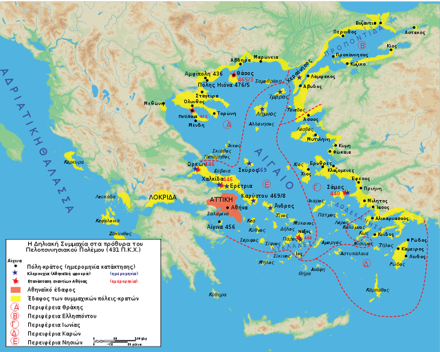
Most of the Greek islands, including Myconos, Lesbos, Patmos and Santorini, are located in the Aegean sea. Some of the Aegean is plants, such as Rhodes and Cos, are so close to the Anatolian peninsula they seem as if they should be part of Turkey not Greece. The Cyclades begin just south of Athens and include Mykonos and Santorini. Rhodes is part of the Dodecanese islands off the southwest coast of Turkey; Lesbos is part of the Northeast Aegean Islands off the northwest coast of Turkey; and the Sporades are small group off the southeastern coast of the Greek mainland. The only two islands which aren't part of a group are Euboea, near the Sporades, and Crete, the largest and southern most Greek island which is just as close to Egypt as it is to Athens.
Features of Greek Geography
Greece is a mountainous peninsular country with many islands. Mountains cover about 80 percent of Greece, with largest mountains in the northern part of the country. The coastline is full of gulfs and inlets and is one of the longest in Europe. About 23 percent of the country is good for agriculture (compared to 21 percent in the U.S.) and most this agriculture land consist of olive groves and vineyards in places that aren't mountainous. About 40 percent of Greece is covered by pasture land and only two percent by forests and woods.
The highest mountain in Greece and the legendary home of the Greek gods, 9,570-foot-high Mt. Olympus, and the famous monasteries of Metora are located in Thessaly. Athens is positioned at the southern end of Central Greece. The Peloponnesus, where Sparta and Corinth are located, is to the west of Athens and seems as if it should be a big island.
There aren't too many forests in Greece especially on the islands. On thing about old civilizations is that they chop down an awful lot of trees, which in Greece have a hard time growing back in the strong sun. Hence most of the mountainous are rocky (first the trees go, then dirt soon follows) and ate covered in grass.None of Greece's rivers, which include the Axious, the Srymon and the Evros, are navigable. The Evros forms the frontier between modern Greece and Turkey.
Greece and the Sea
No matter where people settled in Greece, they were rarely more than 50 miles from the sea. The philosopher Plato noted that the Greeks lived around the sea “like frogs around a pond. ” A deeply indented coastline held between its rocky fingers a sea that could vary from tranquil to turbulent depending on the season and the weather. Most Greek mariners had experienced firsthand the sea's treacherous currents and diabolical whirlpools. [Source: Canadian Museum of History |]
“During the summer months the sea tended to be peaceful. Being an inland body of water the Mediterranean Sea has almost no tides- less than a meter between high and low tides. It has little plankton (that's why its waters are so clear), which means that it doesn't support the extent and variety of sea life seen elsewhere but certainly enough to be both an important and welcome source of food. |
“Surrounded by water, the Greeks nevertheless faced a shortage of fresh water. Compared to many countries, there is a real scarcity of rivers and these often dry up to a trickle in the hot summer months. (Summer temperatures, because of the cloudless skies, are often hotter than in the Tropics.) The lack of rivers is offset somewhat by a plentiful supply of fresh water springs. These were precious and life giving and it is not surprising that they were considered to be sacred sites.” |
Peloponnese
The Peloponnese is rugged peninsula that begins about 75 miles west of Athens. On a map it looks more like an island that an peninsula and only a small narrow isthmus connects it to the mainland. The interior is mountainous and the isolated villages found there have changed little since the Middle Ages. The protected waters along the flat northern coast are quite calm while seas of the rocky southwestern coast are more rough.
The coastline found on the rest of the peninsula is a mixture of harbors, beaches and hills. Between the mountains and the coast are gentle hills and valleys dotted with orange orchards, vineyards, olive groves and fields of vegetables and grain.
Attica, Athens and Sparta
Attica, or the Attic Peninsula, is a historical region that encompasses Athens and surrounding areas. It is a peninsula projecting into the Aegean Sea, bordering on Boeotia to the north and Megaris to the west. The southern tip of the peninsula, known as Laurion, was an important mining region. The history of Attica is closely linked with that of Athens. In ancient times, Attica corresponded with the Athens city-state. Ancient Attica (the classical Athens city-state) was divided into demoi, or municipalities, from the reform of Cleisthenes in 508 B.C., grouped into three zones: urban (astu) in the region of Athens main town, and Piraeus (the port), coastal (paralia) along the coastline, and inland (mesogeia) in the interior
Ancient Athens spread out around the Acropolis. It was a walled city whose main gates — the Dipylon Gate, Sacred Gate and Petriac Gate — were on the northwest side of the city. Other main important places were the Lyceum (outside the walls), the Olympieion, the Pynx, the Aereopagus and the Agora, the main shopping area and gathering place. The ruins of the Lyceum, where Aristotle taught 2,300 years ago, was uncovered in the mid 1990s in downtown Athens.
Sparta was a prominent city-state in Laconia (on the southeastern part of the Peloponnese peninsula) in ancient Greece. In antiquity, the city-state was known as Lacedaemon, while the name Sparta referred to its main settlement on the banks of the Eurotas River in the Eurotas valley of Laconia, in south-eastern Peloponnese. Around 650 B.C. BC, it rose to become the dominant military land-power in ancient Greece.
Corinth
Corinth was a city-state (polis) on the Isthmus of Corinth, the narrow stretch of land that joins the Peloponnese peninsula to the mainland of Greece, roughly halfway between Athens and Sparta. The modern city of Corinth is located approximately 5 kilometers (3.1 miles) northeast of the ancient ruins. Since 1896, archaeological excavations carried out by the American School of Classical Studies at Athens and the the Greek Ministry of Culture have revealed large parts of the ancient city. For Christians, Corinth is well known from the two letters of Saint Paul in the New Testament, First and Second Corinthians. Corinth is also mentioned in the Acts of the Apostles as part of Paul the Apostle's missionary travels. [Source Wikipedia]
Ancient Corinth was one of the largest and most important cities of Greece, with a population of 90,000 in 400 B.C. The Romans demolished Corinth in 146 B.C., and built a new city in its place in 44 B.C. that was later made the provincial capital of Greece. The second book of Pausanias' Description of Greece (A.D. 2nd century) is devoted to Corinth.
Pausanias wrote in “Description of Greece”, Book II: Cornith: “The Corinthian land is a portion of the Argive, and is named after Corinthus. That Corinthus was a son of Zeus I have never known anybody say seriously except the majority of the Corinthians. Eumelus, the son of Amphilytus,1 of the family called Bacchidae, who is said to have composed the epic poem, says in his Corinthian History (if indeed the history be his) that Ephyra, the daughter of Oceanus, dwelt first in this land; that afterwards Marathon, the son of Epopeus, the son of Aloeus, the son of Helius (Sun), fleeing from the lawless violence of his father migrated to the sea coast of Attica; that on the death of Epopeus he came to Peloponnesus, divided his kingdom among his sons, and returned to Attica; and that Asopia was renamed after Sicyon, and Ephyraea after Corinthus. [Source: Pausanias, “Description of Greece,” with an English Translation by W.H.S. Jones, Litt.D. in 4 Volumes. Volume 1.Attica and Cornith, Cambridge, MA, Harvard University Press; London, William Heinemann Ltd., 1918]
“Corinth is no longer inhabited by any of the old Corinthians, but by colonists sent out by the Romans. This change is due to the Achaean League.1 The Corinthians, being members of it, joined in the war against the Romans, which Critolaus, when appointed general of the Achaeans, brought about by persuading to revolt both the Achaeans and the majority of the Greeks outside the Peloponnesus. When the Romans won the war, they carried out a general disarmament of the Greeks2 and dismantled the walls of such cities as were fortified. Corinth was laid waste by Mummius, who at that time commanded the Romans in the field, and it is said that it was afterwards refounded by Caesar,3 who was the author of the present constitution of Rome. Carthage, too, they say, was refounded in his reign.
In the Corinthian territory is also the place called Cromyon from Cromus the son of Poseidon. Here they say that Phaea was bred; overcoming this sow was one of the traditional achievements of Theseus. Farther on the pine still grew by the shore at the time of my visit, and there was an altar of Melicertes. At this place, they say, the boy was brought ashore by a dolphin; Sisyphus found him lying and gave him burial on the Isthmus, establishing the Isthmian games in his honor.
“At the beginning of the Isthmus is the place where the brigand Sinis used to take hold of pine trees and draw them down. All those whom he overcame in fight he used to tie to the trees, and then allow them to swing up again. Thereupon each of the pines used to drag to itself the bound man, and as the bond gave way in neither direction but was stretched equally in both, he was torn in two. This was the way in which Sinis himself was slain by Theseus. For Theseus rid of evildoers the road from Troezen to Athens, killing those whom I have enumerated and, in sacred Epidaurus, Periphetes, thought to be the son of Hephaestus, who used to fight with a bronze club.
“The Corinthian Isthmus stretches on the one hand to the sea at Cenchreae, and on the other to the sea at Lechaeum. For this is what makes the region to the south mainland. He who tried to make the Peloponnesus an island gave up before digging through the Isthmus. Where they began to dig is still to be seen, but into the rock they did not advance at all. So it still is mainland as its nature is to be. Alexander the son of Philip wished to dig through Mimas, and his attempt to do this was his only unsuccessful project. The Cnidians began to dig through their isthmus, but the Pythian priestess stopped them. So difficult it is for man to alter by violence what Heaven has made.
Greek Islands
The Cyclades are a group of 56 inhabited islands that fan out in a southeast direction from Athens towards Crete. Named after the roughly circular shapes formed by the islands, the Cyclades are all beautiful, they all have nice beaches and they all are surrounded by turquoise blue water that is delightful to swim. It is impossible to cover all the islands but we'll try to cover the major ones for you. Milos (9 hours by ferry from Piraeus) has a history that spans 5000 years. Among the treasures unearthed there was the Venus de Milo.
The Aegean Sea is located between Turkey and Greece. The Dodecanese Islands are a group of islands that are located in the southeast Aegean, surprisingly close to Turkey. Rhodes, the main island in the group, is only an hour ferry ride from Turkey (compared to 22 from Athens).. Most of Dodecanese Islands don't have much vegetation. There are hardly any trees and sometimes more rocks than grass. But don't let this discourage you they are still beautiful islands and all of them have nice beaches so I won't even bother to say it for each individual island.
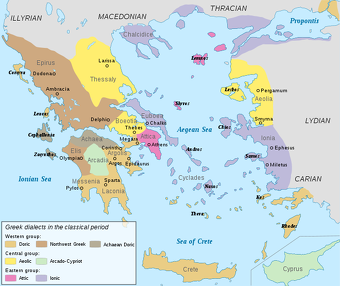
Rhodes (18-24 hours from Pireaus) is the largest island in the Dodecanese and was the former home of the Colossus of Rhodes, one of the Seven Wonders of the World. It is surprisingly lush for a Greek island. Karpathos (7½ hours from Rhodes) is an isolated island south of Rhodes that is a step back in time. In the isolated village of Ólimbos the Greek dialect they speak is so old some of the words date back to Homer's time.
Northeast Aegean Islands are located off the northwestern coast of Turkey and are similar to the other Aegean islands except for one thing. Most of the whitewashed houses have red tiles roofs which the give the villages on these islands a different character. There are scores of nice beaches on each island and also god hiking in the mountains. Samothrace (ferry from Kavala in northern Greece and Lemnos) has the tallest mountain in the Aegean, Fengair (5000 feet) where according to Homer Poseidon watched the Trojan War. The famous Louvre statue, Nike of Samothrace, also known as Winged Victory of Samothrace, was found here.
The Ionian Islands are the group of islands off the west coast of Greek mainland that begin with Zante in the south near Peloponnesus and continue north to Corfu which is within sight of the Albanian border. These islands which lie in the Ionian Sea generally have more trees and receive more rain than their Aegean counterparts. The Ionian island most popular with tourists is Corfu. The one most well known to students who read their lessons is Ithaca, the home of Ulysses.
Greek Parts of Turkey
The European part of modern Turkey between Istanbul, Bulgaria and Greece is called Thrace. European and Asian sides of modern Turkey are divided by the Bosporus, Sea of Marmara and the Dardanelles. Only three percent of the land mass lies west of the Bosporus on the European side. Modern Turkey and Greece share a common border in Thrace. Many islands that are only a few miles off the coast of Turkey, and seem as if they should belong to Turkey, are actually part of Greece.
Bosporus is Greek means “ox ford,” a reference to a legend to the goddess Io who swan across the strait in the form of a cow. The first man to cross the Bosporus on a bridge was King Darius of Persia who lashed together a line of galleys at the straits narrowest point in the 6th century B.C. that allowed his 70,000 troops to cross the waterway on their way to do battle with the Greeks. A similar legend has Xeres crossing the Dardanelles.
The Dardanelles (125 miles southwest of Istanbul) is a strategically-located 38-mile-long strait between the Aegean Sea and the Sea of Marmara that is similar to the Bosporus but wider and longer yet still is less than a mile across in some places. Unlike the zigzagging Bosporus, the Dardanelles is relatively straight and canal-like and easier for ships to negotiate than the Bosporus. Known in ancient times as Hellespont, it is, according to Greek mythology, the place where Leander tried to swim to his lover Hero but drowned on the way; The broken-hearted Hero ended up drowning as well.
Anatolia, Asia Minor
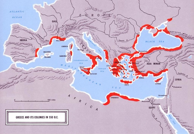
Parts of ancient Greek civilization were located around the Black Sea and on the western coast of Turkey, which sits upon a large peninsula between the the Black and Mediterranean Seas called Anatolia (a Greek name meaning “sunrise”) or Asia Minor (the name the Romans used).
About 26 percent of Anatolia is covered by forests; 11 percent is occupied by grasslands; and 30 percent is good for agriculture. Most of this land is in coastal plains in the south and west. Other crops are raised in irrigated areas along river and in mountain valleys. A wide plateau — that is cold in the winter and hot in summer — occupies the central part of Anatolia. Ir rises progressively towards the east and is broken by the valleys of more than a dozen major rivers including the Tigris and Euphrates. Most of the rest of Anatolia is mountainous or hilly. The central and eastern parts of the country are the most desert-like regions of Turkey.
High mountains ring the interior on all sides but the West. There are more than 20 peaks over 10,000 feet. The eastern Black Sea mountain ranges — which included the Kachkar range and the Pontic Alps — parallels the Black Sea and rise up rather abruptly from the Black Sea coast and recive a lot of rain on the northern Black Sea side and dry on the south side. In the south the Tarsus mountains sweep down almost to narrow fertile plane along the Mediterranean coast.
At one time much of Anatolia was covered with forests, but the 36 civilizations needed wood for their houses and cooking fires, and now many of the forests are gone. Most of the remaining forest are in the north and in Black Sea region, which includes the Istanbul area and is surprisingly lush and green. The Aegean and Mediterranean coasts are drier. The plant life found here resembles the scrubby vegetation of southern California or Greece.
Image Sources: Wikimedia Commons, The Louvre, The British Museum
Text Sources: Internet Ancient History Sourcebook: Greece sourcebooks.fordham.edu ; Internet Ancient History Sourcebook: Hellenistic World sourcebooks.fordham.edu ; BBC Ancient Greeks bbc.co.uk/history/; Canadian Museum of History, Perseus Project - Tufts University; perseus.tufts.edu ; MIT Classics Online classics.mit.edu ; Gutenberg.org, Metropolitan Museum of Art, National Geographic, Smithsonian magazine, New York Times, Washington Post, Live Science, Discover magazine, Natural History magazine, Archaeology magazine, The New Yorker, Encyclopædia Britannica, "The Discoverers" and "The Creators" by Daniel Boorstin. "Greek and Roman Life" by Ian Jenkins from the British Museum, Wikipedia, Reuters, Associated Press, The Guardian, AFP and various books and other publications.
Last updated September 2024

